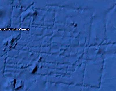
I was poking around the ocean floor with the new Google Earth 5.0 the other day, in the area southeast of the Azores, and I found this strange, what... formation? The horizontal border of the grid near the bottom of the image is over 100 miles long. There's nothing else like it in the region.
Click here to see a larger picture.

Now, I know that some freak geological formations can resemble purposeful structure. This seems to be an extreme case however. And very large, roughly 13,000 square miles according to the Google Earth "ruler".
A discussion has begun already over at the Google Earth forums on this feature, several people have stumbled on it apparently, like me, since the release of Google Earth 5.0 featuring the ocean floors. If you have any thoughts on this, post comments here.
Update Feb 20: This feature is catching a lot of attention... see "Has Atlantis Been Found Off The Coast of Africa?"
What else may await further armchair exploration? As the data sets become more fine-grained, determined explorers are certain to find things of interest. I found some sunken dock structures and ships in an ancient megalithic port, now submerged. (In shallow waters near some coastal areas the imagery is good enough to see these details underwater).
Remember that the imagery used in Google Earth, Mars, and Sky, has not yet necessarily been seen by humans, let alone examined in detail; discoveries are happening already, and many more await... have you looked into the Google Sky deep-field yet?

Related updates:
Dutch schoolteacher finds new class of astronomical object with Galaxy Zoo
Hanny's Blog / Galaxy Zoo blog discussion
GalaxyZoo
Google Earth reveals fish trap made from rocks 1,000 years ago off British coast
The Official Google Blog is saying this grid is an artifact of sonar-mapping by ships. I'm not entirely convinced- any other spots like this?
ReplyDeleteview the post